
(606) 679-7908 500 W.O. Newell Drive, Somerset, KY 42501 CTAF 122.8 · AWOS-3 120.050
02

Weather at the field, now and next.

The AWOS-3 at Lake Cumberland Regional Airport reports to the national feed every 20 minutes, and the National Weather Service office in Jackson, Kentucky writes the TAF and the forecast for the square of ground the runway sits on. Both are here, with the radar out of Jackson and the day's light computed for the field. None of it is a briefing.

02Aviation Weather Center · AWOS-3 on the field · TAF by NWS Jackson KY

The field now

AWOS-3 120.050 · reports every 20 minutes

Live
KSME fetching the latest observation…
Wind
–
Visibility
–
Ceiling
–
Altimeter
–
Temp / dew
– / –
Density alt
–

Loading the METAR…

TAF: loading, or see aviationweather.gov

Source: aviationweather.gov · METAR and TAF for KSME · TAF issued by NWS Jackson, Kentucky · NOTAMs
By radio or phone

The same observation, read aloud from the field

AWOS-3
120.050
By phone
(606) 679-5710
CTAF
122.8
Briefing
1-800-WX-BRIEF

FAA Chart Supplement SE, effective 29 Oct 2026 · Louisville Flight Service · no tower, no ATIS

Density altitude at 927 feet

What a warm day does to the runway

TemperatureDensity altAbove field
13.2°C · 56°F927 ftstandard day
15°C · 59°F1,145 ft+218 ft
25°C · 77°F2,333 ft+1,406 ft
30°C · 86°F2,927 ft+2,000 ft
35°C · 95°F3,521 ft+2,594 ft
38°C · 100°F3,878 ft+2,951 ft

The AWOS adds a density-altitude remark to its broadcast once it is 1,000 ft or more above the field. The live figure, worked from the current observation, is on the board.

Standard pressure 29.92 inHg, dry air; humidity and a low altimeter push it higher · field elevation 927.3 ft, FAA NASR effective 29 Oct 2026

03National Weather Service, Jackson KY · gridpoint JKL 18,23 · alerts for zone KYZ079

The next few days.

The National Weather Service forecast for the grid square that holds the field, in the office's own words, refreshed every half hour. Any watch, warning or advisory for Pulaski County hangs above it while it is in force.

Loading the forecast from the National Weather Service. If it does not arrive, read it at forecast.weather.gov.

Source: National Weather Service, Jackson, Kentucky · point forecast for 37.0536, -84.6156, gridpoint JKL 18,23 · alerts for forecast zone KYZ079, Pulaski County · °F, day highs and night lows · a percentage is the chance of precipitation · the full forecast

04NWS radar KJKL, Jackson KY · USNO sun formula, computed in the browser

The radar picture, and the day's light.

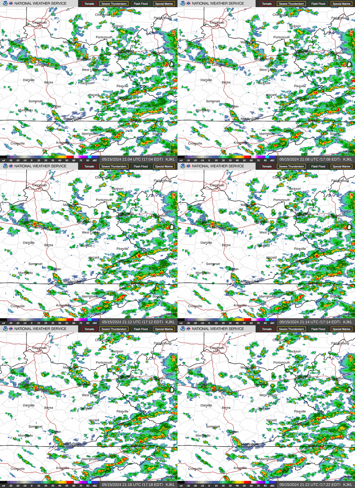
The nearest weather radar is the National Weather Service's at Jackson, Kentucky, about 70 nautical miles east-northeast of the field. Sunrise, sunset and civil twilight are worked out for the field's own coordinates; the beacon runs sunset to sunrise.

Live radar loop from the National Weather Service radar at Jackson, Kentucky: precipitation echoes over eastern and south-central Kentucky, with the field toward the lower left of the picture
Radar loop from NWS KJKL at Jackson, Kentucky. The field lies west-southwest of the radar, inside the picture. Public domain; reload the page for the latest frames. The full KJKL radar page

The day's light

Computed for the field · Eastern time · beacon runs sunset to sunrise

Civil dawn
–
Sunrise
–
Sunset
–
Civil dusk
–
Beacon
White & green · sunset to sunrise
Lights
MIRL, PAPI and REIL, pilot-controlled on CTAF 122.8

U.S. Naval Observatory sunrise and twilight formula, worked in your browser for 37.0536, -84.6156 on today's date · civil twilight ends with the sun 6° below the horizon · beacon and lighting per the FAA Chart Supplement SE, effective 29 Oct 2026

05FAA Chart Supplement SE, effective 29 Oct 2026 · Aviation Weather Center

Who else is reporting, and the briefing you still need.

The nearest fields that report their own weather, with the frequency to tune on the way in. When the AWOS on the field drops out of the national feed, the board above falls back to Monticello, then London-Corbin, and says so under the readout.

Nearby stations

StationReportsFrom KSME
KSME Somerset AWOS-3 120.050 · METAR every 20 min · TAF on the field
KEKQ Monticello AWOS-3PT 118.825 · (606) 348-0862 16.5 nm224° true
KBYL Williamsburg AWOS-3 119.575 25.2 nm128° true
KLOZ London-Corbin ASOS 119.075 · METAR · TAF 26.3 nm085° true

Each station links to its METAR and TAF at aviationweather.gov · distances and true bearings from the KSME reference point · sensors and frequencies per the FAA Chart Supplement SE, effective 29 Oct 2026

Before you fly

Nothing on this page is a briefing. Flight Service gives one at 1-800-WX-BRIEF (1-800-992-7433) or at 1800wxbrief.com; the Graphical Forecasts for Aviation at aviationweather.gov cover the route; NOTAMs for the field file under SME. Then fly the current plate.

Louisville Flight Service, 1-800-WX-BRIEF · NOTAM file SME · FAA Chart Supplement SE, effective 29 Oct 2026 · charts expire every 28 days