
Field data and approaches.
What a transient or based pilot asks the desk at KSME, with the FAA record as the spine: frequencies, both runway ends, the lights, the minimums off the current plates, services, fees, hangars, hours and the fields within fifty miles. Lake Cumberland Regional Airport, Somerset, Kentucky, three miles south of downtown and eleven minutes from the lake.
- CTAF / UNICOM122.8
- AWOS-3120.050
- ILS I-SME · RWY 05109.3
- Indianapolis Center124.625
- Runway 05/235,801 × 100 ft
- Elevation927 ft
Frequencies and field data.
Class E surface area, no tower, no ATIS. Weather comes from the field's own AWOS-3 every twenty minutes, IFR clearances from Indianapolis Center or by phone, and the briefing from Louisville Flight Service.
Frequencies
| CTAF / UNICOM | 122.8 |
|---|---|
| AWOS-3 | 120.050phone (606) 679-5710 |
| ILS/DME I-SME, Rwy 05 | 109.3Chan 30 · course 048° |
| Indianapolis Center | 124.625371.925 UHF · London RCAG |
| Clearance delivery | 317-247-2411by phone, no RCO on the field |
| Flight Service | 1-800-WX-BRIEFLouisville FSS |
| London VOR/DME | LOZ 116.55 · 276° / 24.3 NM |
| Livingston VOR/DME | LVT 114.35IAF for the ILS |
| NOTAM file | SMENOTAM-D · current NOTAMs |
FAA Chart Supplement SE p.303, effective 29 Oct to 26 Nov 2026 · approach and departure: Indianapolis Center
The field
| Identifiers | FAA SME · ICAO KSME · IATA SME |
|---|---|
| Elevation | 927 ft MSLsurveyed 927.3 ft |
| Reference point | 37°03'12.9"N 84°36'56.3"W37.0536, -84.6156 |
| Magnetic variation | 5°WFAA 2005 epoch · 5.81°W by WMM-2025 for Nov 2026 |
| Airspace | Class E surface area · no control tower · no ATIS |
| Pattern | 1,927 MSL / 1,000 AGLleft traffic both runways · altitude from the airport's site; the FAA publishes none |
| Sectional | Cincinnati, edition of 29 Oct 2026 |
| Based aircraft | 4932 single, 3 multi, 7 jet, 7 helicopter · FAA 5010 |
| Attended | Mon–Fri 0700–1800 · Sat–Sun 0800–1800 · hours and after-hours |
| Activated | August 1952 · last FAA inspection 15 Apr 2025 |
FAA NASR and Form 5010, effective 29 Oct 2026 · pattern altitude: flylcra.com, read 8 Nov 2026

Runway 05/23, end by end.
One asphalt runway in good condition, true 043 and 223, magnetic about 048 and 228. Both thresholds are displaced, so the landing distance is shorter than the pavement: 5,287 feet on 05 and 5,500 feet on 23.
- 5,801 ftlength
- 100 ftwidth
- 18/F/C/X/TPCN
- 48.5 · 68 · 125S · D · 2D, thousands lb
- 043° / 223°true alignment
FAA NASR, effective 29 Oct 2026 · Asphalt, good condition · MIRL · PAPI · REIL, pilot-controlled on CTAF · 2018 state pavement index: runway 75, apron 84, taxiway 87
Both ends
| Runway end | 05 | 23 |
|---|---|---|
| Threshold elevation | 910.8 ft | 921.0 ft |
| Markings | Precision | Non-precision |
| Displaced threshold | 514 ft | 300 ft |
| PAPI | P2R · 3.00° · TCH 60 ft | P2L · 3.00° · TCH 54 ft |
| REIL | Yes | Yes |
| Traffic pattern | Left | Left |
| TORA / TODA / ASDA | 5,800 ft | 5,800 ft |
| Landing distance (LDA) | 5,287 ft | 5,500 ft |
| Controlling obstacle | 13-ft tree, 289 ft from the threshold, 32 ft right | 17-ft tree, 281 ft from the threshold, 317 ft right |
| Straight-in approaches | ILS or LOC · RNAV (GPS) with LPV | RNAV (GPS) with LP |
FAA NASR runway-end records, effective 29 Oct 2026 · TORA, TODA and ASDA as declared · obstacles measured from each threshold

Lights on request, keyed on 122.8.
The edge lights, both PAPIs and both sets of REILs are pilot-controlled on the CTAF. The whole field was relit with LEDs and a new beacon between 2020 and 2022.
The remark, as printed
ACTVT REIL RWY 05 & 23; PAPI RWY 05 & 23; MIRL RWY 05/23 - CTAF.FAA Chart Supplement SE p.303, airport remarks, effective 29 Oct 2026
Key the lights on 122.8 before you need them. At night the beacon runs on its own.
- Runway edge
- MIRL, Rwy 05/23
- PAPI
- PAPI (P2R) Rwy 05 · PAPI (P2L) Rwy 23
- REIL
- Rwy 05 and Rwy 23
- Beacon
- White & green · sunset to sunrise
- Wind indicator
- Lighted · segmented circle
- Relight
- 332 LED fixtures and a new beacon, 2020 to 2022, $1.2 million state-funded
Chart Supplement SE and NASR, effective 29 Oct 2026 · relight: Kentucky Department of Aviation closed-projects ledger, Airfield Lighting $1,200,000 (2022)
Approaches and minimums.
Three procedures to the one runway: an ILS the City of Somerset owns and operates, an LPV down to 250 feet, and GPS to Runway 23. The lines below are read from the current plates. Fly the plate, not the page.
Straight-in minimums
| Line | DA / MDA | HAT | Vis A/B | Vis C/D |
|---|---|---|---|---|
| ILS or LOC RWY 5Amdt 1, 02 Oct 2025 · DME required | ||||
| S-ILS 5 | DA 1,482 | 555 | 1⅝ SM | 1⅝ SM |
| S-LOC 5 | MDA 1,540 | 613 | 1 SM | 1¾ SM |
| RNAV (GPS) RWY 5Orig-C, 21 Mar 2024 · WAAS CH 65941 · W05A | ||||
| LPV | DA 1,177 | 250 | ¾ SM | ¾ SM |
| LNAV/VNAV | DA 1,547 | 620 | 1¾ SM | 1¾ SM |
| LNAV | MDA 1,480 | 553 | 1 SM | 1⅝ SM |
| RNAV (GPS) RWY 23Amdt 2A, 21 Mar 2024 · WAAS CH 53641 · W23A | ||||
| LP | MDA 1,580 | 653 | 1 SM | 1⅞ SM |
| LNAV | MDA 1,660 | 733 | 1 SM | 2 SM |
DA and MDA in feet MSL, HAT in feet · the LPV is the lowest approach on the field · plates AL-5424 (FAA), cycle 2611
Circling
| From | Cat A | Cat B | Cat C and D |
|---|---|---|---|
| Runway 5 procedures (ILS, LOC, RNAV) | 1,580 · 1 SMHAA 653 | 1,700 · 1 SMHAA 773 | 2,100 · 3 SMHAA 1,173 |
| RNAV (GPS) RWY 23 | 1,660 · 1 SMHAA 733 | 1,700 · 1 SMHAA 773 | 2,100 · 3 SMHAA 1,173 |
- Takeoff
- Takeoff Minimums Amdt 4A. Runway 23 amended to 300-1½ by FDC 5/0494. The SE-1 takeoff minimums page carries Runway 05 and the departure procedure.
- Alternate
- Not authorised when local weather is not available. SE-1 alternate minimums.
Circling MDAs as printed on the cycle 2611 plates · takeoff and alternate minimums: FAA d-TPP SE-1
ILS/DME I-SME, the restrictions
GS unusable beyond 3° left and 6° right of course; autopilot-coupled approach NA below 1,620 ft; DME unusable beyond 20° right of course.FAA NASR ILS record for I-SME, effective 29 Oct 2026
The plate adds that DME is required and that the Monticello (EKQ) altimeter setting raises the ILS DA to 1,526 feet when the local setting is not received. CAT I, localizer 109.3 on channel 30, glideslope 332.0 MHz, owned and operated by the City of Somerset.
Restrictions quoted from the FAA record · plate notes read from the cycle 2611 ILS or LOC RWY 5 plate, 8 Nov 2026
The plates
- ILS OR LOC RWY 05FAA d-TPP cycle 2611 · 1 · PDF
- RNAV (GPS) RWY 05FAA d-TPP cycle 2611 · 0C · PDF
- RNAV (GPS) RWY 23FAA d-TPP cycle 2611 · 2A · PDF
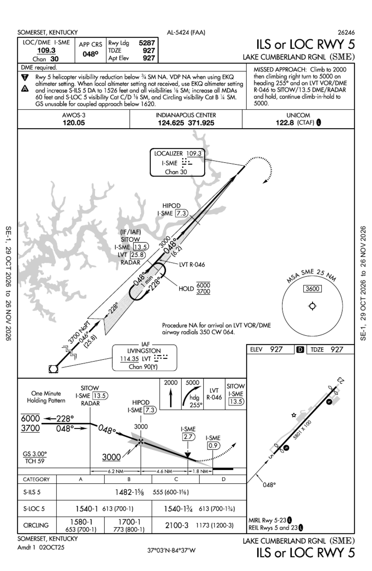
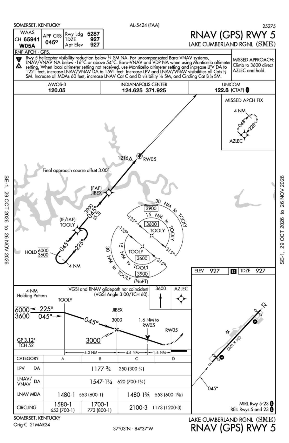
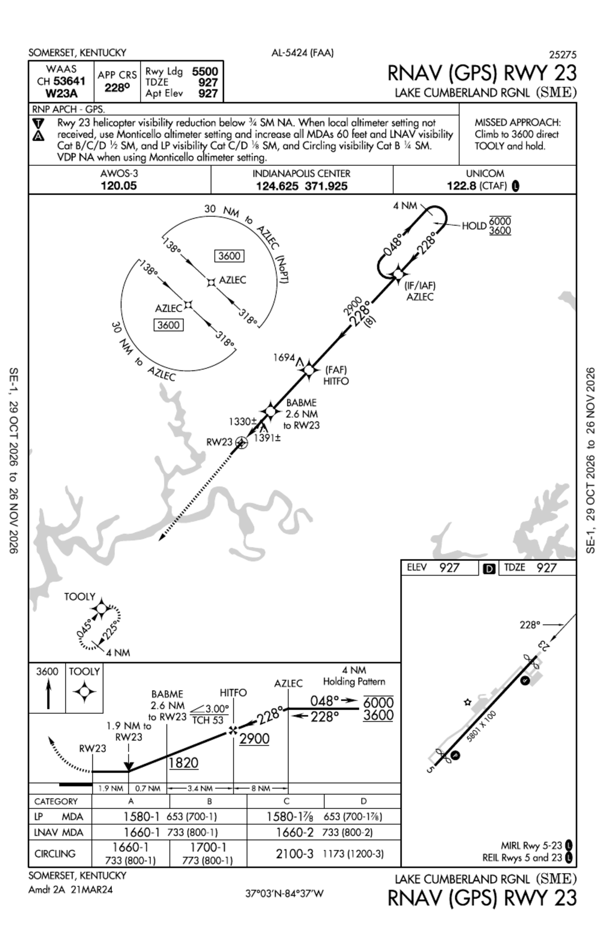
Plates expire every 28 days; this cycle ends 26 Nov 2026. No FAA airport diagram is published for SME. Not for navigation: fly the current plate, get a briefing, check NOTAMs.
Navaids, airspace and who to call.
No tower and no radar on the field. Indianapolis Center works the airspace through the London remote site; on the ground, clearances come by phone.
Navaids
| ILS/DME I-SME | 109.3 · Chan 30Rwy 05 · CAT I · course 048° · GS 332.0 MHz · City of Somerset |
|---|---|
| London VOR/DME | LOZ 116.55 · 276° / 24.3 NMradial and distance to the field |
| Livingston VOR/DME | LVT 114.35 · Chan 90(Y)IAF for the ILS · R-046 to SITOW |
| RNAV (GPS) RWY 5 | WAAS CH 65941 · W05AIAF TOOLY · FAF JIBEX · missed to AZLEC |
| RNAV (GPS) RWY 23 | WAAS CH 53641 · W23AIAF AZLEC · FAF HITFO · missed to TOOLY |
| MSA | 3,600 ftwithin 25 NM of SME, ILS plate |
NASR navaid and ILS records, effective 29 Oct 2026 · WAAS channels, fixes and MSA from the cycle 2611 plates
Airspace and ATC
- Airspace
- Class E surface area · no control tower · no ATIS
- CTAF
- 122.8 · UNICOM 122.8
- Center
- Indianapolis Center 124.625371.925 UHF · London RCAG
- Clearance
- 317-247-2411clearance delivery by phone
- Flight Service
- 1-800-WX-BRIEFLouisville FSS · NOTAM file SME
- Weather
- AWOS-3 120.050(606) 679-5710 · METAR every 20 min · TAF by NWS Jackson
- Pattern
- 1,927 MSL / 1,000 AGLleft traffic both runways
- Traffic
- Air-medical helicopters are based on the field (PHI Air Medical, since June 2022); Somerset Community College trains here
Chart Supplement SE p.303, effective 29 Oct 2026 · pattern altitude from the airport's site · PHI base: Commonwealth Journal, 8 Jun 2022
Services on the field.
The Airport Board runs the FBO itself; there is no third-party operator. The FAA records the basics and the airport lists the rest.
What the FAA records
- Fuel
- 100LL and Jet A with Prist · posted prices
- Repair
- Minor airframe and powerplant (S2)
- Parking
- Transient hangars and tie-downs
- Air ambulance
- On the field
- Landing fee
- None in the FAA record. The airport's own schedule says call for price; most fees are waived with a qualifying fuel purchase.
- ARFF
- Index A, available on request
- Air carrier
- Closed to unscheduled operations with more than 30 seats
- Customs
- Not a customs airport
- Military
- Landing rights
FAA Form 5010 and NASR, effective 29 Oct 2026 · landing fee: flylcra.com/fees, read 8 Nov 2026
What the airport lists
- 100LL and Jet Afull service by truck, self-serve 24/7
- Courtesy and crew carscomplimentary, two-hour limit
- Pilot loungewith a flight-planning area
- Wi-Fi
- GPU$75 per use
- Lavatory service
- Passenger terminalcomplimentary refreshments
- Hangar rentals and tie-downsovernight and monthly
- Rental vehiclesEnterprise, 1.5 miles
Third-party directories add catering, a conference room and pilot supplies. The airport's own list does not, so ask the desk before you count on them.
flylcra.com/api/airport-info, read 8 Nov 2026 · third-party items: FlightAware and AirNav listings
Fees and hangars.
The airport publishes its own schedule and says most fees are waived with a qualifying fuel purchase. Call the desk for a landing-fee quote; the ramp fees below are the ones the FBO entered on GlobalAir.
Fee schedule
| Landing fee | Call for priceFAA record: none | |
|---|---|---|
| GPU | Per use | $75 |
| Courtesy car | Two-hour limit · first come, first served · no reservations | $0 |
| Overnight hangar | General aviation · by availability | $50 |
| Overnight hangar | Corporate · by availability | $100 |
| Ramp fee | Super-midsize jetFBO-entered on GlobalAir, 8 Oct 2026 | $100 |
| Ramp fee | Heavy jetFBO-entered on GlobalAir, 8 Oct 2026 | $200 |
| Fuel | 100LL, full service · per gallon, taxes includedevery price, discounts and contract fuel · posted 8 Nov 2026 | $6.85 |
Airport schedule, flylcra.com/fees, read 8 Nov 2026 · "most fees are waived with a qualifying fuel purchase" · ramp fees as entered by the FBO on GlobalAir
Hangars and rates
- $275per monthT-hangar, Row A41 × 32 ft · manual sliding door
- $313.50per monthT-hangar, Row B42 × 32 ft · bi-fold electric door
- AskavailabilityCorporate hangarcurrently home to two light jets and a super-midsize
- Basedon the fieldCommunity hangarair-medical helicopters
- $50 / $100per nightOvernightgeneral aviation / corporate, by availability; tie-downs on the ramp
For the T-hangar waitlist, send the airport a note or call the desk at (606) 679-7908. A 12,000 sq ft storage hangar is in design with FY2025 FAA funding.
flylcra.com/api/hangars, read 8 Nov 2026 · storage hangar design: FAA AIP FY2025, $153,900

Attended hours.
The FBO desk keeps the FAA's published hours. The pump never closes. For anything after the desk closes, call ahead.
The desk
- Mon to Fri
- 7 a.m. to 6 p.m.1200–2300Z‡
- Sat and Sun
- 8 a.m. to 6 p.m.1300–2300Z‡ · FAA record
- Self-serve fuel
- 24 hours100LL and Jet A at the pump
- Clock
- Eastern time · ‡ one hour earlier in daylight time
Open with the airport: the weekend opening hour. The FAA record says 8 a.m. on Saturday and Sunday; the airport's own site and AirNav say 7 a.m. every day. The sign above follows the FAA record until the airport confirms. If you need the desk at 7 on a weekend, call first.
After hours
AirNav carries the airport's line that after-hours operations are available on request. The airport has not published an after-hours number or procedure, and pilots' reports run both ways: one found the building locked at 7:30 in the evening, another was met by the line crew with a courtesy van. Arrange it before you depart.
After the desk closes you can still fuel at the pump, tie down on the ramp, and reach the AWOS on 120.050 or (606) 679-5710.
FAA NASR: Mon–Fri 0700–1800 · Sat–Sun 0800–1800 · The airport advertises 7 am to 6 pm every day; self-serve fuel is available 24/7 · after-hours: AirNav FBO record and pilot comments, 26 Apr 2024 and 28 Jul 2026
Fields within fifty miles.
Alternates and fuel stops around the lake, by distance from the reference point. Weather frequencies and phones appear where the research sheet carries them; the Chart Supplement has the rest.
| Field | NM | True | Weather |
|---|---|---|---|
| KEKQWayne County · Monticello, KY | 16.5 | 224° | AWOS-3PT 118.825(606) 348-0862 |
| 18IMcCreary County · Pine Knot, KY | 24.1 | 153° | No weather sensor |
| KBYLWilliamsburg-Whitley County · Williamsburg, KY | 25.2 | 128° | AWOS-3 119.575 |
| KLOZLondon-Corbin, Magee Field · London, KY | 26.3 | 085° | ASOS 119.075 · TAF |
| KDVKStuart Powell Field · Danville, KY | 32.2 | 347° | Not listed |
| KRGACentral Kentucky Regional · Richmond, KY | 37.2 | 021° | Not listed |
| KAASTaylor County · Campbellsville, KY | 38.1 | 299° | Not listed |
| 6I2Hoerter Field · Lebanon-Springfield, KY | 46.0 | 320° | Not listed |
| KJAUCampbell County · Jacksboro, TN | 48.3 | 153° | Not listed |
| 1A6Middlesboro-Bell County · Middlesboro, KY | 50.0 | 122° | Not listed |
Distances in nautical miles and true bearings from 37.053583, -84.615639 · FAA NASR, effective 29 Oct 2026 · weather frequencies and phones from the research sheet, 8 Nov 2026 · each identifier opens AirNav
Tools, coordinates and density altitude.
The sites pilots already use, pointed at KSME, plus the reference point in a form that pastes into a flight-planning app and the density altitudes a summer afternoon brings.
Reference point
- Degrees
- 37°03'12.9"N 84°36'56.3"W
- Elevation
- 927 ft MSL
- Variation
- 5°W5.81°W by WMM-2025, Nov 2026
- ILS course
- 048° magnetic
- Pattern
- 1,927 MSL / 1,000 AGL
Airport reference point, FAA NASR, effective 29 Oct 2026 · variation: FAA 2005 epoch and WMM-2025
Density altitude at 927 ft
| Air temperature | Density altitude |
|---|---|
| ISA, 13.2°C | 927 ft |
| 15°C | 1,145 ft |
| 25°C | 2,333 ft |
| 30°C | 2,927 ft |
| 35°C | 3,521 ft |
| 38°C | 3,878 ft |
Dry air at 29.92 inHg. The AWOS announces density altitude once it is 1,000 feet or more above the field. The live figure is on the conditions page.
Standard-atmosphere computation for the field elevation, research sheet 8 Nov 2026 · AWOS-3 120.050